- Mon - Fri: 8.00 am - 4.30 pm
UMMSCC
About us
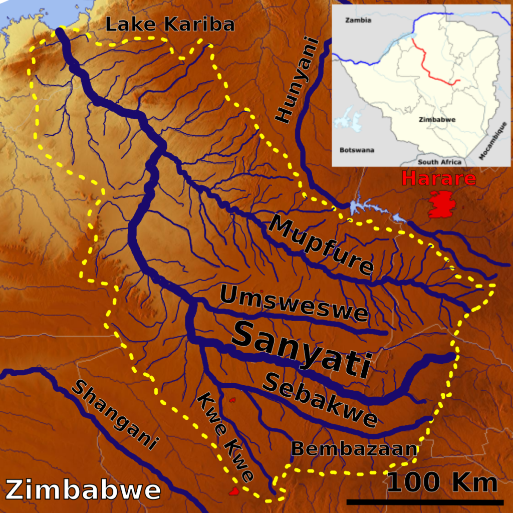
Upper Middle Mupfure Sub-Catchment Council (UMMSCC) is a statutory water management body in Zimbabwe established in law by the Water Act of 1998 (Chapter 20:24) section 24 and Statutory Instrument 47 of 2000, under the auspices of the Ministry of Lands, Agriculture, Water, Fisheries and Rural Development. The UMMSCC manages water in the Upper Middle Mupfure Sub-Catchment, a river basin delimited on the basis of hydrological boundaries. Upper Middle Mupfure Sub-Catchment Council is one of the ten Sub-Catchment Councils in Sanyati Catchment.
It stretches from Mhondoro communal lands in the East of the Sanyati Catchment to Poole Dam in Chegutu. UMMSCC is made up of various stakeholders of the economy which comprise of groundwater users, communal farmers, small scale commercial farmers, resettled farmers, large scale commercial farmers, small scale miners, large scale miners, rural district councils, urban town councils, industries and any other deemed group by the respective Sub-Catchment Council.
Upper Middle Mupfure
Catchment area
Upper Middle Mupfure Sub-Catchment falls under sub-hydrological zone CUF3. Our catchment area covers Chegutu, Selous, Mhondoro Mubaira and portion of Norton. The major rivers found in Upper Middle Mupfure Sub-Catchment (CUF3) being Mupfure, Saruwe, Chirundazi, Nyawiye, Chimbo, Gweshe, Nyangweni, Muchenarota, Makwiro, Munyukwe, Nyundo and their tributaries.
Water users
The major water users in Upper Middle Mupfure Sub-Catchment are: Agriculture, Mining, Urban Council (Mubaira), Institutions, Recreation and Rural District Council amongst others.
How we were born
We are a statutory water management body Established by an Act of Parliament.
What we do
We are mandated to monitor water use (both surface and ground water).